![](/images/other/stat-length.png)
Tête de Cade-le Beausset-08-10-21
Christiancordin
User
![Length](/images/other/stat-length.png)
Length
10.2 km
![Max alt](https://static1.geolcdn.com/siteimages/upload/files/1508320355ic_sort_altitude_max_24dp.png)
Max alt
532 m
![Uphill gradient](https://static1.geolcdn.com/siteimages/upload/files/1508320355ic_sort_den_pos_24dp.png)
Uphill gradient
224 m
![Km-Effort](/images/other/stat-length.png)
Km-Effort
13.2 km
![Min alt](https://static1.geolcdn.com/siteimages/upload/files/1508320355ic_sort_altitude_min_24dp.png)
Min alt
351 m
![Downhill gradient](https://static1.geolcdn.com/siteimages/upload/files/1508320355ic_sort_den_neg_24dp.png)
Downhill gradient
226 m
![Boucle](https://static1.geolcdn.com/siteimages/upload/files/16400158638029165_repeat_loop_refresh_sync_direction_icon.png)
Boucle
Yes
Creation date :
2021-10-08 09:32:46.482
Updated on :
2021-10-08 17:28:26.507
![Walking](https://static1.geolcdn.com/sitytour/trail-icons/101.png)
3h57
Difficulty : Medium
![Scan this QR Code to open this trail in the SityTrail application](https://capi.geolives.com/qq0zvz2zws4bq2lad0pu/sitytour/trails/2962672/qr.png?size=200)
FREE GPS app for hiking
About
Trail Walking of 10.2 km to be discovered at Provence-Alpes-Côte d'Azur, Var, Le Beausset. This trail is proposed by Christiancordin.
Description
Maison des 4 Frères-la bastide blanche-fond du vallon de l'Oure-plateau du Tarron-tête de Cade-ancien four à chaux-hauts du vallon de l'Oure-fours à chaux et à cade et charbonnière.
Positioning
Country:
France
Region :
Provence-Alpes-Côte d'Azur
Department/Province :
Var
Municipality :
Le Beausset
Location:
Unknown
Start:(Dec)
Start:(UTM)
728478 ; 4790741 (31T) N.
Comments
Trails nearby
![Trail Walking Le Beausset - Trace_Quatre_Freres - Photo](https://media.geolcdn.com/t/375/260/a076bf67-1e95-4bda-8264-007e64206af1.jpg&format=jpg&maxdim=2)
![Walking Walking](https://static1.geolcdn.com/sitytour/trail-icons/101.png)
Trace_Quatre_Freres
Walking
Very difficult
(1)
Le Beausset,
Provence-Alpes-Côte d'Azur,
Var,
France
![](/images/other/stat-length.png)
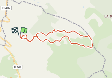
14.8 km | 19.6 km-effort
4h 26min
![](https://static1.geolcdn.com/siteimages/upload/files/16400158638029165_repeat_loop_refresh_sync_direction_icon.png)
Yes
![Trail Walking Le Beausset - Tête du Cade par abime de Maramouyé - Photo](https://media.geolcdn.com/t/375/260/ext.jpg?maxdim=2&url=https%3A%2F%2Fservices.sitytrail.com%2FGeolivesWS%2FDownloadMedia.ashx%3FTrailID%3D1038187%26Media%3Dfix__20180911112303.jpg)
![Walking Walking](https://static1.geolcdn.com/sitytour/trail-icons/101.png)
Tête du Cade par abime de Maramouyé
Walking
Very easy
(1)
Le Beausset,
Provence-Alpes-Côte d'Azur,
Var,
France
![](/images/other/stat-length.png)
12.4 km | 16.1 km-effort
3h 36min
![](https://static1.geolcdn.com/siteimages/upload/files/16400158638029165_repeat_loop_refresh_sync_direction_icon.png)
Yes
![Trail Walking Cuges-les-Pins - Jean de lorette, grotte et mémorial - Photo](https://media.geolcdn.com/t/375/260/7f0fa6ce-b146-4d44-9642-97b327cde2ed.jpg&format=jpg&maxdim=2)
![Walking Walking](https://static1.geolcdn.com/sitytour/trail-icons/101.png)
Jean de lorette, grotte et mémorial
Walking
Difficult
(1)
Cuges-les-Pins,
Provence-Alpes-Côte d'Azur,
Bouches-du-Rhône,
France
![](/images/other/stat-length.png)
11.2 km | 14.6 km-effort
3h 18min
![](https://static1.geolcdn.com/siteimages/upload/files/16400158638029165_repeat_loop_refresh_sync_direction_icon.png)
Yes
![Trail Walking Le Beausset - le beausset abime de Maramouyé - Photo](https://media.geolcdn.com/t/375/260/d520a71d-a30d-4c7b-b268-ac5e18a04afb.jpg&format=jpg&maxdim=2)
![Walking Walking](https://static1.geolcdn.com/sitytour/trail-icons/101.png)
le beausset abime de Maramouyé
Walking
Very easy
(1)
Le Beausset,
Provence-Alpes-Côte d'Azur,
Var,
France
![](/images/other/stat-length.png)
9.6 km | 13.4 km-effort
4h 32min
![](https://static1.geolcdn.com/siteimages/upload/files/16400158638029165_repeat_loop_refresh_sync_direction_icon.png)
Yes
![Trail Walking Signes - grotte du mounoi signes - Photo](https://media.geolcdn.com/t/375/260/ext.jpg?maxdim=2&url=https%3A%2F%2Fservices.sitytrail.com%2FGeolivesWS%2FDownloadMedia.ashx%3FTrailID%3D266184%26Media%3Dfix__20140413111146.jpg)
![Walking Walking](https://static1.geolcdn.com/sitytour/trail-icons/101.png)
grotte du mounoi signes
Walking
Medium
(1)
Signes,
Provence-Alpes-Côte d'Azur,
Var,
France
![](/images/other/stat-length.png)
17 km | 21 km-effort
4h 45min
![](https://static1.geolcdn.com/siteimages/upload/files/16400158638029165_repeat_loop_refresh_sync_direction_icon.png)
Yes
![Trail Walking Le Beausset - la tête de cade. Maison des 4 frères le Beausset - Photo](https://media.geolcdn.com/t/375/260/0d9e1f30-3a4b-476b-b15d-3d4d5c048e2b.jpg&format=jpg&maxdim=2)
![Walking Walking](https://static1.geolcdn.com/sitytour/trail-icons/101.png)
la tête de cade. Maison des 4 frères le Beausset
Walking
Difficult
Le Beausset,
Provence-Alpes-Côte d'Azur,
Var,
France
![](/images/other/stat-length.png)
9.7 km | 12.4 km-effort
3h 34min
![](https://static1.geolcdn.com/siteimages/upload/files/16400158638029165_repeat_loop_refresh_sync_direction_icon.png)
No
![Trail Walking La Cadière-d'Azur - LA CADIERE - Photo](https://media.geolcdn.com/t/375/260/a2408c77-3028-41f8-8edb-6dd660fdfb6a.jpg&format=jpg&maxdim=2)
![Walking Walking](https://static1.geolcdn.com/sitytour/trail-icons/101.png)
LA CADIERE
Walking
Medium
(1)
La Cadière-d'Azur,
Provence-Alpes-Côte d'Azur,
Var,
France
![](/images/other/stat-length.png)
10.4 km | 14.4 km-effort
3h 16min
![](https://static1.geolcdn.com/siteimages/upload/files/16400158638029165_repeat_loop_refresh_sync_direction_icon.png)
Yes
![Trail Walking Le Beausset - Les 4 frères - Photo](https://media.geolcdn.com/t/375/260/0fd45fee-5c1e-487f-bd6a-34aa8cf23ac9.jpg&format=jpg&maxdim=2)
![Walking Walking](https://static1.geolcdn.com/sitytour/trail-icons/101.png)
Les 4 frères
Walking
Difficult
Le Beausset,
Provence-Alpes-Côte d'Azur,
Var,
France
![](/images/other/stat-length.png)
13 km | 17.2 km-effort
3h 53min
![](https://static1.geolcdn.com/siteimages/upload/files/16400158638029165_repeat_loop_refresh_sync_direction_icon.png)
Yes
![Trail Walking Le Castellet - Roche Redonne depuis Ste Anne du Castelet - Photo](https://media.geolcdn.com/t/375/260/cebdae65-72ef-4e31-931e-0efa1e0463c0.jpg&format=jpg&maxdim=2)
![Walking Walking](https://static1.geolcdn.com/sitytour/trail-icons/101.png)
Roche Redonne depuis Ste Anne du Castelet
Walking
Difficult
(1)
Le Castellet,
Provence-Alpes-Côte d'Azur,
Var,
France
![](/images/other/stat-length.png)
11 km | 15.7 km-effort
3h 34min
![](https://static1.geolcdn.com/siteimages/upload/files/16400158638029165_repeat_loop_refresh_sync_direction_icon.png)
Yes